|
|
For managing, manipulating and mapping GPS data |
|
Description Versions GPS Receivers Features Function List Download Registration Things to Do
Conditions of Use
User Group

Home Description Versions GPS Receivers Features Function List Download Registration Things to Do
Conditions of Use
User Group
Home Description Versions GPS Receivers Features Function List Download Registration Things to Do
Conditions of Use
User Group
|
GeneralGPS utility is the perfect companion for your GPS. You can use it to edit, store and manage waypoints, routes, tracks easily.Manage Your DataYou can create separate files of GPS data and then just upload the ones you need when you need them, allowing you to only work with a sub-set of routes and waypoints in the field. Why not have files for different states, routes that you only use occasionally, etc. This frees up space on your GPS and keeps you from having to cycle through hundreds of waypoints to initiate a "Goto."It is also much easier to add comments and edit waypoint names being able to actually type on a full keyboard instead of having to cycle through characters on the rocker keypad on your GPS. Create RoutesYou can easily create routes from your waypoints or from track logs.Import Waypoint, Route and Track Information from Google Maps.You can use either Google Maps or Google Maps UK to get directions to your destination and in a few clicks upload a complete set of waypoints, route and a track for your trip. This technology has developed quite a following and will no doubt appear on mobile phones from companies like o2 in the not too distant future. This is really slick. A real keystroke saver! For more details see the Help Topic in GPSU on "Google Maps".MappingOne of the great strengths of GPS Utility is the ability to work with maps and GPS information graphically. You will either need a scanner or some other way to get maps as Windows bitmap files onto your PC for most of the map functions.Sort, Edit and Manage Waypoints Graphically.You can see where your waypoints, tracks and routes are in relation to each other. You can move them, edit them, draw a circle or a box around a group and delete, upload or otherwise work with them.Create Waypoints, Tracks and Routes from maps.Once your register a bitmap, you can click any point on it and create a waypoint, a track or a route.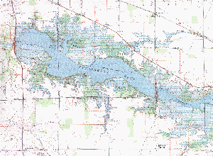
Scanned Topographic Map Section of Huntington Reservoir Make Your Own Maps.You can collect track data from a trail and then overlay it on a topographic (or other) map, complete with waypoints and annotations.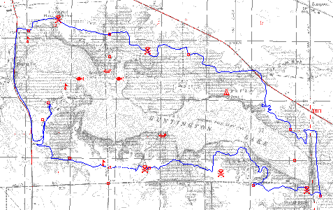
Mountain Bike Trail Over-laid on Topographic Map Make "Maps" for Your GPS.Even if you have a GPS that is not capable of using G-charts or other maps, you can trace a track from a map and upload it to your GPS giving you a virtual outline map.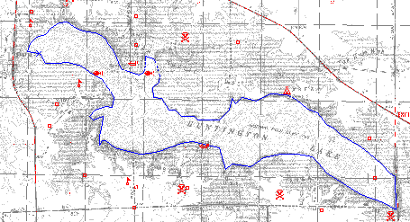
Track tracing edge of Huntington Reservoir 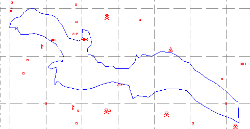
"Track Trace" Map of Huntington Reservoir Program Strengths
|